Walking on Lycian Way Kalkan


Your starting point: As the march begins from above the village of Islamlar, you will need a car to take you there. Your local representative can give you details of the exact location.
Your walk begins with the ruins of an old settlement with spectacular views of the mountains inland and the Patara plains. When you look back and follow your steps, you will see that your halfway point is a rocky ledge. Below is the village of Bezirgân, which sits on a flat plateau. Enjoy a casual lunch at one of Islam's trout restaurants before returning to the car.
Starting point: The small village of Gelemis near Patara Beach.
Head through the pine forests and you will reach the magnificent dunes, which have recently become a movie venue. Walk over the sand to the shoreline, left by the water, towards the café. There you can have a cold drink before following the inner path to Gelemis, passing the ancient ruins of Patara, the best archaeological site in the region.
Your starting point: Go to the center of Kas and set off from the port.
Follow the road along the coast from the harbour past Great Çakıl Beach (Büyük Çakıl Plajı) before heading inland and into the countryside. Keep an eye out for turtles and sunbathing lizards before returning to the beach and cafes at Limanağzı Beach. On the way back to Kas, take an exhilarating 15-minute boat tour on the sea or take a refreshing dip.
Your starting point: The village itself. This is a slow circular walk.
Bezirgan, a traditional working village, is really a place where time stops. As they have done for centuries, the inhabitants of Kalkan retreat here in the summer to escape the silence and the heat of the coast. The land is suitable for farming, and in the early season, you will see horse ploughs when working in the fields. Look at the cedar tree warehouses (warehouses) once used to store grain in winter and enjoy a Turkish beer in the teahouse under the walnut tree in the center of the village. If you visit in May, the valley is covered with red ferrets.
Your starting point: The village of Akbel, 2 km above Kalkan. The walk lasts 4 hours.
This route follows the ruins of the ancient aqueduct Delikkemer, which once took spring water from the village of Islam to the ancient city of Patara. Follow the Lycian Way signs from Akbel and get the red and white road markers. Halfway between your starting point and Patara, you will come across a huge stone wall with a pipeline carved from the top. It is hiding in an olive grove now, and it is easy to miss. Follow the curves of the hill until the path descends into the ruins of Patara, where you can have a beer and swim before taking the bus to Kalkan.
The Lycian Way has been named one of the 10 best and most scenic walking routes in the world by various magazines published abroad in the past years.
How Many Km is the Lycian Way?
The route, which starts from Hisarönu (Ovacik) in Fethiye, Mugla province, ends in the village of Geyikbayırı in Antalya province with the 555-kilometer route. It is also possible to start the route from Antalya and finish in Fethiye.
Where is the Lycian Way?
Burdur-Gölhisar in the north on Teke peninsula, Mugla-Köyceğiz in the west, and Antalya in the east are considered the homeland of 'Land of Light' Lycia.
The Lycian people, who call themselves 'Trmmili', have a reputation for a fondness for their freedom and warrior traditions. The Lycian people, who established numerous cities to be described as eagle's nests in this region with harsh geography and warm climate, had a unique culture with the house and temple-type rock-sarcophagus tombs they created by processing the local limestone.
The Lycian Union, whose capital is Patara, has set an example for many current state models with its understanding of autonomous governance. The Lycian people, who served in maritime, piracy, and mercenary service, had a matriarchal society.
Named after the Lycian people, the walking route is more than twenty ancient cities as well as Fethiye, Oludeniz, which is already a tourist activity, Butterfly Valley, Kabak Bay, Yediburunlar, Patara Beach, Kalkan, Kaş, Kekova, Demre, Finike, Pirate Bay, one of the longest natural beaches in the world with 18 kilometers, Gelidonya (Stony Cape) Lighthouse, Adrasan Bay, Musa (Olympus) Mountain, Cirali Beach, the highest peak in Europe and Turkey on the coast (2366) It extends along the Mediterranean coastline through natural beauties such as Tekirova, Kes Bosphorus, Goynuk Canyon, Goynuk.
The course not only follows the shore but also goes up steep slopes in places and down to the beaches and harbors. The route, which also passes through the highlands and woodlands, reaches its highest point above the cedar forests at 1800 meters on Tahtali Mountain.
The Lycian Way, which also offers alternatives for those who want to relax, swim, or sunbathe, passes through or near many seaside villages where you can benefit from hostels, restaurants, and beach facilities.
The route also includes Kalabantia, Sidyma, Pydnai, Letoon, Xanthos, Patara, Phellos, Antiphellos, Sebada, Apllania, Aperlai, Teimussa, Simena, Sura, Andriake, Myra, Belos, Gagai, Melanippe, Olympus, Chimera (Yanartaş), Phaselis ancient cities as well as the ancient cities of St Nicholas (Santa Claus), Alakilise, Pastor's Rock, Gedelme Castle, Delikkemer and Xanthos. The sites of Xanthos and Letoon are UNESCO world heritage sites.
Lycian Way Walking Route
Lycian road walk- Lycian road signs
Lycian Way signs will allow you to easily follow the route
Anyone who loves nature and hiking can easily walk the Lycian Way, which is marked with the French Grande Randonnee system and yellow directional signs are placed at the junction points.
Red-and-white lines marked at intervals of every 50 meters on the paths and about every 200 meters on the dirt roads makes it easier for nature lovers. 'Cross' signs drawn in red paint say that the path has strayed and that you should not enter the path at the beginning of the sign.
Red-and-white markings drawn on top of each other remind you that you are at a crossroads. These signs are periodically renewed by volunteers.
However, it is sometimes possible to lose the signs due to natural conditions, the opening of new forest roads, and destruction by humans. In such a case, going back to the last sign and calmly re-exploring the environment will allow you to find the right way. Thanks to the marking system made on both sides of things such as trees and rocks, the starting point of the Lycian Way, Fethiye, or Antalya can be selected.
The guidebook, prepared in Turkish, English, and German, which you can find in D&R shops, contains all kinds of information about the Lycian Way trails.
There is a map showing the route and environmental characteristics inside the back cover. The book also includes GPS points and altitude charts and detailed descriptions of each part of the route. With the help of maps and recipes, you can take a safe and enjoyable walk along the Lycian coast
Since the winter months are quite mild in the region dominated by the Mediterranean climate, the walking season is long. The Lycian Way has favorable conditions that can be walked eleven months of the year due to global warming.
Nevertheless, the best and most beautiful time to walk in the spring season, when you can see the snow-covered hills and the flowers covering the face of the soil together, and the October-November period, when the heat and humidity are gradually decreasing. It should also be noted that at the peaks of the mountains, all four seasons can occur during the day.
If you are not walking in high places, it is quite warm for walking activity between mid-May and mid-September. Rain and storms may occur in December and January. From January to early April there is usually snow above 1500 meters. Showers may occur in November-February.
Lycian Way stages, Hisaronu (Ovacik)-Faralya, Faralya-Kabak Bay, Kabak Bay-Alca, Al-Yediburunlar, Yediburunlar-Gavurağılı, Gavurağılı-Patara, Patara-Kalkan, Kalkan-Sarıbelen-Gökçeören, Gökçeören-Kaş, Kaş-Kekova, Kekova-Demre, Demre-Alakilise-Finike, Karaöz-Gelidonya Lighthouse-Adrasan, Adrasan-Olympos-Cirali, Cirali-Beycik, Cirali-Tekirova, Tekirova-Phaselis-Gedelme, Beycik-Tahtali Mountain-Gedelme, Gedelme-Göynuk, Göynuk-Hisarçandir and Hisarçandir-Deerbayiri
This long route: Fethiye Bosphorus village is separated into 2 alternative routes in Patara Delikkemer and Cirali regions and then reunited.
Those who want to walk the 555-kilometer-long Lycian Way can divide the route into different stages and take it with 3-5-7-10 daily activities.
To walk all at once, it is necessary to allocate 25-40 days according to performance and conditioning.
The Lycian Way walking trail where the first long international sign system in Turkey and is considered among the world's top 10 hiking trails. So don't worry, you won't get lost. As a result of the works commissioned by Kate Clow in the 1990s, the paths were mapped and marked with red and white lines. Apart from this system called Grande Randonnee, another guide is the yellow direction signs at the intersections. You can also benefit from GPS coordinates prepared by travelers and of course the map applications we use every day, but you will find that the successful marking system on the road will be sufficient alone. Also, local people always support the walkers. Don't hesitate to knock on their door to buy fresh local produce or stay overnight because they're all familiar and open to guests at all times.
Since it is the most important tourism center in Turkey, accommodation and transportation opportunities in the region are rich. Dalaman or Antalya airport two starting points of the course may be the appropriate transportation alternative for Fethiye and Antalya. All districts from major cities can be reached by intercity or local buses.
Fethiye, Oludeniz, Faralya, Kabak Bay, Patara, Kalkan, Kaş, Kekova, Demre, Finike, Adrasan, Olympus, Cirali, Tekirova, Çamyuva, Kemer and Goynuk settlements can be found in hotels and hostels for every budget.
In addition, in some villages along the route, accommodation options have increased in recent years with the use of traditional village houses as hostels.
There are many natural campsites and camping facilities on the Lycian Way. You can benefit from the camps in Kabak Bay, Patara Özlen Çay, Hot Peninsula, Andriake Port, Olympos, Cirali, Goynuk regions.
Lycian passengers should have a good walking shoe with waterproof (gore-tex) and soft-bottomed wrists that necessarily grasp the ankles, quick-drying trousers, and socks, sweat-out thermal T-shirt, hat, a tulle to wipe your sweat and protect your neck, sunglasses and cream, swimwear, towels, supported shoulder columns, and a waist-belted backpack to distribute the load evenly, spare laundry, raincoat, a thin fleece.
Undoubtedly some of the must-haves of the backpack are the compass, map, whistle, pocketknife, headlight, camera, lighter, spare battery, a small first aid kit.
Lycian Way Cycling
Lycian road walk
Get ready to see such sights on the Lycian Way
Part of the Lycian Way, most of which passes through the trails, is suitable for mountain biking.
Professional downhill and single truck enthusiasts can cross the entire course by carrying the bike on their backs in certain places. However, using alternative forest and village routes, you can try the bike route, some on the Lycian Way and partly via parallel side roads.
In the meantime, let us remember that for many years, the Lycian Way Ultra Marathon has been held, which travels about 250 kilometers of the Lycian Way in 6 days.
Marathon, an international sports organization; an extreme activity with a high degree of difficulty, based on struggle and conditioning, promising unforgettable experiences to participants.
Let us remember that this year will be held between 27-29 September 2019.3)
We had a hard time at first on the Sarnıçbaşı-Bezirgân course, which is a really challenging course. We were proud of ourselves for arriving in Bezirgan and resting on that great plain. We share our experience with all the details below.
Total Walking Time: 5-6 Hours with Breaks
Kalkan (Sahil) – Sarnıçbaşı: 5 KM
Sarnıçbaşı – Bezirgân: 6 KM
Difficulty Level: Challenging
Water Consuming: Since this course is a challenging hiking trail, you will consume at least 2 Liters of water up to Sarnıçbaşı. Unfortunately, there is no facility or grocery store when continuing from Sarnıçbaşı to Bezirgan, so we recommend taking more water with you. There are water wells in certain kilometers on the Sarnıç-Bezirgân course. If you get 3-4 liters of water from the markets before setting off from Kalkan, it will be enough.
Food: You can easily finish the day with a strict breakfast and small snacks before setting off from Kalkan. There are two grocery stores in Bezirgan, there is also a tea garden called Dervish's Place and there is a hostel. You will not have any trouble eating in Bezirgan.
Accommodation in Bezirgan is quite easy, do not worry. First, since it is a very flat grassy woodland, an extremely comfortable tent can be thrown. As soon as you get to Bezirgan, you will see that area. There is also a fountain in that section, and there are two grocery stores nearby.
Other than that, there is a coffee called Dervis' place. You can throw a tent in his garden. That is where you can meet your eating needs. It also has a shower and toilet.
Lycian Road Sarnıçbaşı – Bezirgân Course – Dervis' Place
We had already organized a hostel because we did not know, so we rushed to our hostel to relax. There is only one hostel in Bezirgan.
Owlsland Hostel and owner Mr. Erol. He saw us walking towards the hostel and picked us up in his car. He gave us a great welcome. Anyway, the most enjoyable part of the Lycian way is that this sharing is for us.
Mr. Erol has a well-equipped hotel, and we enjoyed chatting with him very much. He was also so humble that he and Kate learned from the locals, not from him, that he had contributed a lot to the drawing of the course.
Lycian Road Sarnıçbaşı – Bezirgân Course – Owlsland Pension
We paid 300 TL for the stay for two people one night. We said goodbye to Mr. Erol by paying 450 TL in cash with meals and drinks.
DETAILS ABOUT THE COURSE
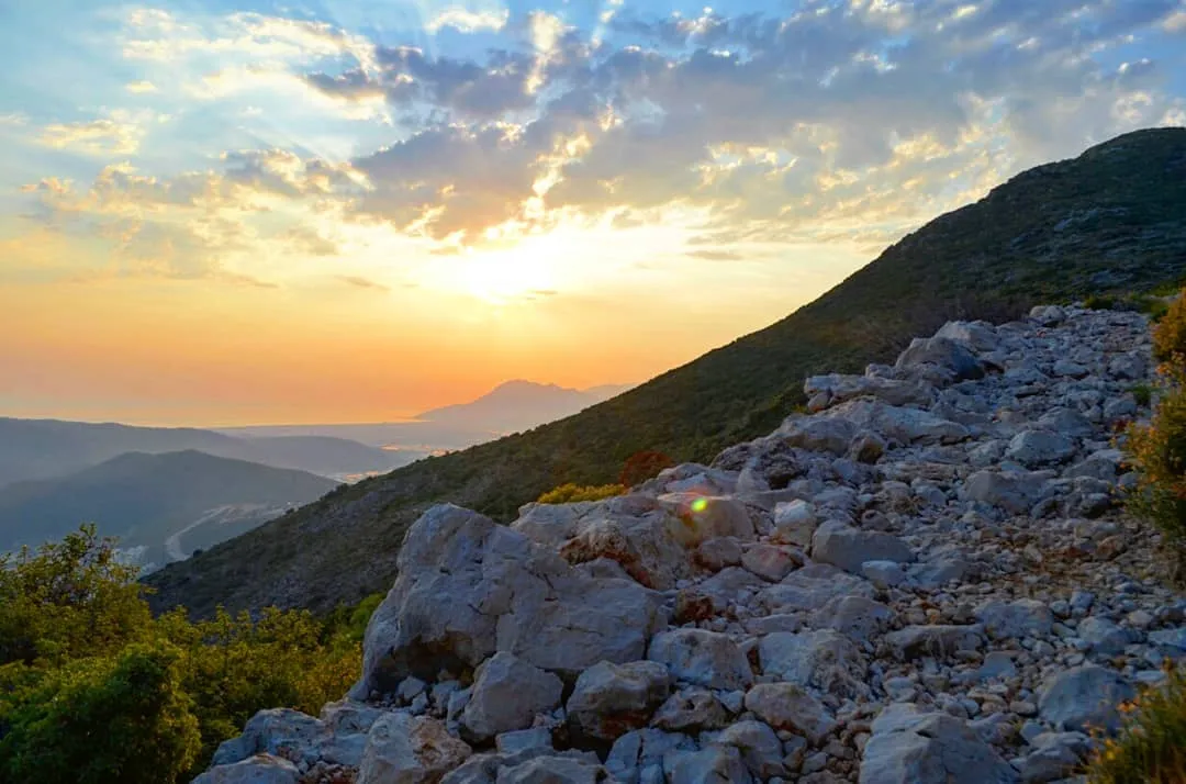
After setting off from Kalkan beach, you pass through the steep streets and then when you reach the Fethiye-Kaş road, you continue in the direction of Kaş. We did not see many signs here and the phone app we downloaded came to our rescue. After walking about 2 km, we arrived at the Lycian Way sign. As we learned from Ayhan Bey at Kaleo Pension, where we stayed in Kalkan, many people jumped this part by taxi and started walking directly from Sarnıçbaşı because it was an asphalt road. You can also consider this option.
After the sign, our steep climb begins. Sarnıçbaşı – Bezirgân course is a difficult course. It is going to be really challenging, especially if you are walking in a post-May period. First, you are going to climb 2.5 miles of slopes. The place is steep in places, but mostly not a very steep slope. However, since it is not a very tree-lined area, the slope is increasingly challenging. If you can, I suggest you do not use too heavy backpacks. It was quite tiring as we had 11-12 kg of Engin and 16-17 kg of bags. Engin even had to carry my bag from time to time.
The distance is about 5.5 km. 2.5 miles of this distance is challenging. If you have survived this part, you will finish the rest with ease because the last mile and a half is downhill.